- 首頁
- 西螺采風
- 源來如此
源來如此
【Scroll down for English text】
西螺的地名
1. 稱「西螺」(sorean)
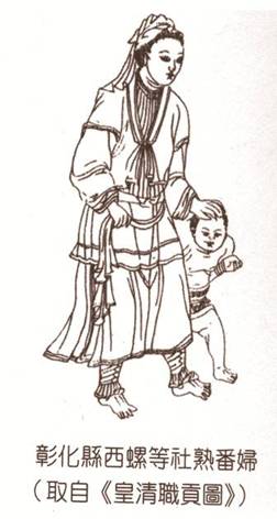
(1) 荷蘭人統治臺灣時期,依據最早住在這塊土地上的原住民平埔族巴布薩人,稱呼此地之譯音,而於當時文獻上記錄為「sorean」、 「soared」、「sorean」、「soeron」、「sailei」、「sairei 」 或「賽麗」等多種不同方式出現。
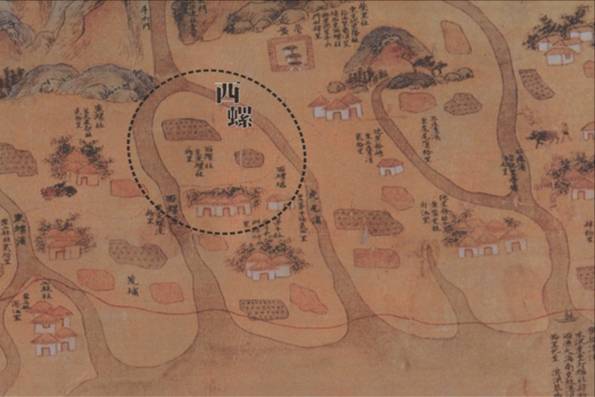
(2) 根據清「康熙台灣輿圖」中,有「西螺社」的登載。相傳與古稱「東螺社」的今彰化縣北斗鎮隔著濁水溪相對稱,而得名為「西螺社」。或有因濁水溪之「濁」字之河洛語與「螺」字相同音而得名。
(3) 乾隆5年 (西元1740年)劉良璧重修《台灣府誌》時,即有「西螺街」、「西螺堡」之記載,可見當時之西螺已頗具發展了。
2. 稱「螺陽」
(1) 早期至此地開墾的漢人之中,來自大陸福建省惠安縣者居多。開拓先祖為追思故土惠安縣(即螺陽)而以螺陽之名為故鄉文化傳揚。
(2) 亦有依濁水溪位置「北辰南陽」之情況而得名之說。古稱「山南水北稱為陽」,雖然今之西螺地屬濁水溪之南,但因古代濁水溪主支流頻繁改道,昔日西螺稱螺陽時,不無可能當時西螺在濁水溪主流之北。
康熙台灣輿圖
西螺的故事
雲林縣西螺鎮位於台灣最大的河流-濁水溪南岸,自古以來,因為土地肥沃富饒,人口聚集快速,在荷治時期(西元1624年),今漢光里番社即成平埔族巴布薩人聚落。西螺開發甚早。清康熙二十二年,台灣為清朝版圖,西螺先劃屬於諸羅縣。
在雍正元年(西元1723年)時,西螺改屬彰化縣管轄。漳州詔安人張廖家族廖朝孔等入墾,墾首王玉成開墾西螺中北部(今廣福、永安、振興、中和、福興、光華、中興等里),築西螺庄,當時即有街廓型態,鍾、李、林、吳、程、陳各氏族接繼而入,西螺範圍逐漸擴展。
乾隆六年(西元1741年),台灣府志中記載有西螺街事項,當時因西螺颱風大雨,水災不斷,所以街上的廣興宮、福興宮、伽藍爺廟,市仔頭土地公廟相繼創建。西螺街發展最早的區域為,緊鄰著濁水溪的大菜園及東市場一帶(今大園里、永安里),人口隨著水陸運輸而來,市集商號建築於西螺東區成形後,人口發展由東北角往西南邊移動。廣福宮創建於乾隆二十五年(西元1760年),座落於新街尾端,可知西螺於乾隆時期,街廓由東市場區已延伸向南,發展至今廣福宮一帶,範圍極大。
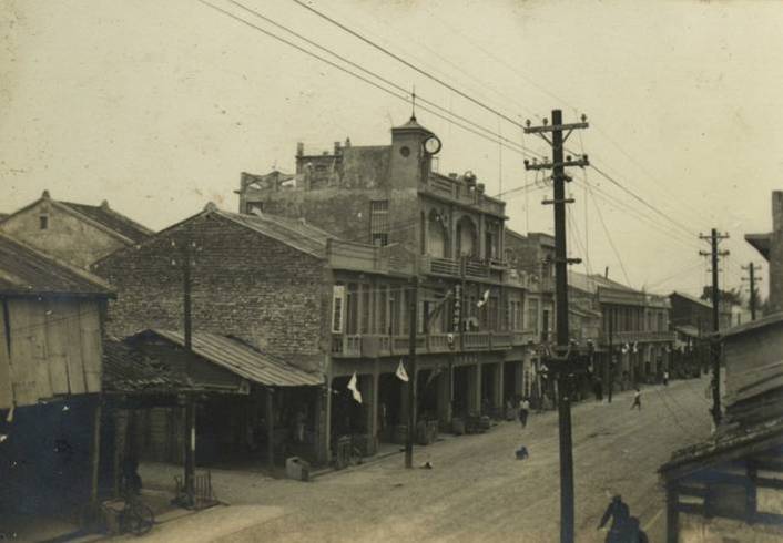
明治二十八年(西元1895年),台灣成為日本的殖民地。台灣因為氣侯合宜,農作物四季豐收,日政府為增加台灣進貢日本天皇的獻納,所以進行大規模的建設。為貫徹完全殖民,教育文化亦有嚴格管制規定。明治三十二年(西元1899年),雲林郵便局。電信局、出張所成立,西螺公學校並開始招生。大正六年(西元1917年)西螺信用組合成立、西螺自動車株式會社、台灣商工銀行,西螺派出所、西螺女子公學校…相繼成立。昭和十二年(西元1937年),西螺實施市區改正,延平路拓寬拉直,西螺大橋建橋墩,農田溝渠等大量公共建設,讓原本物產豐富的西螺街,一躍成為現代化便利的農業鄉鎮。西元1899-1940年是西螺街市的黃金時期。
昭和五年(西元1930年),嘉南大圳完工通水後,西螺農田因受惠而盛產稻米,成為當時嘉南平原的米倉。所產「獻納米」因進貢給日本天皇,而馳名全台。其它因水質、氣候、溫度、溼度等優勢條件,而生產的農產及加工品,如蔬菜、豆皮、醬油、醬菜及麻糬等,產業技術升級而提高產量。一直到今天,西螺的醬油、蔬菜、豆皮等產業仍為全台之冠。
西螺基礎資料
1. 地理位置
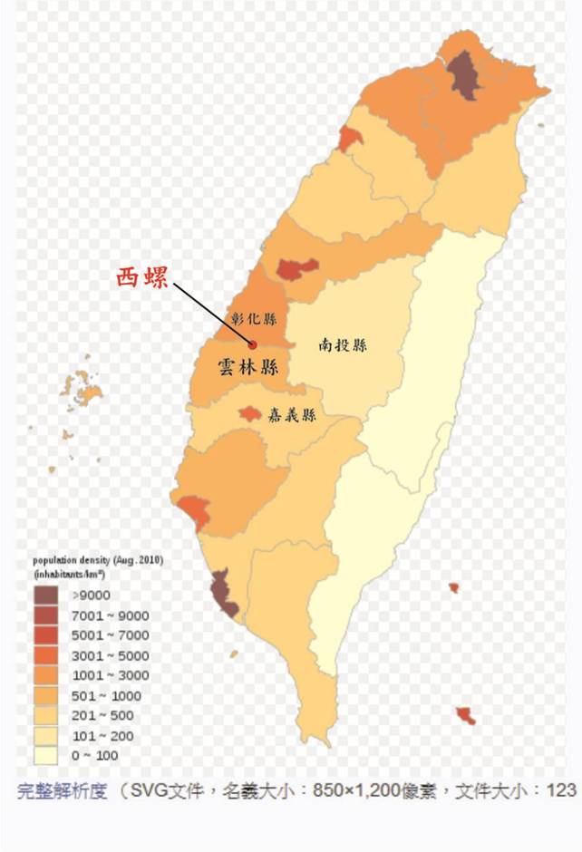
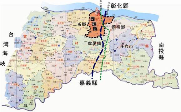
西螺地處北緯23°48’,東經120°27’一帶。位於雲林縣北端,北臨濁水溪與彰化縣為界,東連莿桐鄉、西接二崙、南面與虎尾毗鄰。 面積4.993公頃,屬濁水溪沖積扇平原。
2. 地形面積
西螺鎮土地屬濁水溪沖積扇平原,地勢平坦,高度不超過40公尺,呈東往西遞減。東西寬約9.4公里,南北長約10.9公里,總面積為49.7985平方公里。約4,993公頃。約占雲林縣面積的3.858%。
3. 氣候
西螺屬副熱帶季風氣候,一月平均溫度在16℃以上,七月平均溫度在29℃以上,年平均溫度在23℃以上,全年適合農作物生產。氣候宜人,沒有寒冬。西螺屬平原區,無高山依恃,雖有季風但無地形雨。氣流不易在此停留,雨量較丘陵地少。雨量集中在夏季4-8月中,秋冬時期較少降雨。 需仰賴灌溉維持農作物生長
4. 土地利用
因為濁水溪沖積扇平原,地勢又平坦,灌溉與排水設施優良,西螺土地被政府劃分為最適合農業生產的一級良田,農地占總面積的74%。 是全台最重要的農業生產區之一。
5. 人口發展
西螺鎮人口近十年間,民國 91 年–民國 101 年(2002 - 2012)人口數由 50198 人減為 47798人,至 2019 年 6 月止僅剩45940 人,年年衰退呈負成長狀態。西螺鎮27里,以漢光里、正興里及中興里三地區人口較多,而以永安里、中和里、福興里人口最少。
台灣日治時期,以居住人口數來劃分村里範圍,當時永安里、中和里、福興里、光華里為西螺人口密度最高,文化發展最繁盛之處。此四里為西螺老街範圍,後因面積小,發展受限且人口流失嚴重,成為人口最凋零之區域。目前四里總和3,371人,尚不及一個漢光里5,161人之多,由西螺各里人口消長,明顯可見西螺的街市發展,由東北往西南移動的狀態。
Name origin of Xiluo
1. A region「Xiluo」(sorean) ...
(1) When Dutch colonists came to Taiwan in past, they transliterated the original name of aboriginal people, the Babu tribe, into Dutch language. The names「sorean」, 「soared」, 「sorean」, 「soeron」, 「sailei」, 「sairei 」 or「saili」 and many more emerge from documents of that period.
(2) The name “Xiluo” was mentioned for the first time in the maps of Taiwan during the reign of Emperor Kangxi of Qing dynasty. According to the ancient name of Beitou town in Zhanghua county “Dongluo” (which means “eastern shell”), Xiluo (“western shell”) was so called because it was placed almost equidistant from it if Zhuo Shui river was taken as the symmetry axis. Moreover the name “Luo” was presumably inspired by the name “Zhuo” as they sound similar.
(3) In 1740, on the fifth year of Qianlong reign, when Liu Liangbi revised the “Annals of Taiwan government”, he came in contact with records about “Xiluo street” and “Xiluo village”, which means that at that time the town was quite developed.
2. ... Known as「Luo Yang」
(1) The Majority of the early inhabitants who came to Taiwan were Han tribes from the Fujian Province in Hui’an county in mainland China, also called Luo Yang. So in order to honor their hometown name in mainland China, they called the new place “Luo Yang”.
(2) It depends also on the Zhuo Shui river location which is in the middle of Taiwan. In ancient times Xiluo was called “Shan Nan Shui Bei Cheng Wei Yang”, which means “Place called Yang located between northern mountains and a southern water”. Although nowadays Xiluo is displaced in the south of Zhuo Shui river, in the past the main branch had many smaller streams. So when Xiluo was called with this ancient name, Luo Yang, maybe the town was located in the north of the river.
History of Xiluo
Yunlin County is situated in the south of Taiwan's largest river, Zhuo Shui River. Since ancient times, given that the land is fertile and rich of minerals, its population started growing significantly. During Dutch colonist period (1624), Babu tribes, the aborigine people of Xiluo, settled at Hanguang. Xiluo started to develop very early. On the 22nd year reign of Kangxi, Emperor of Qing dynasty, Taiwan was a Qing territory and Xiluo was assigned to Zhuluo county.
In the first year of Chinese Emperor Yongzheng’s reign (1723), a request came to assign Xiluo under the jurisdiction of Changhua County.The Zhang Liao family from Zhao’an in Zhangzhou county in mainland China, under the lead of Ken Wangyucheng, settled and started to build their first establishments in the north-central part of today’s town, Guangfu, Yongan, Zhenxing, Zhonghe, Fuxing, Guanghua and Zhongxing. Later on, this place was extended even more, when Zhong, Li, Lin, Wu, Cheng and Chen clans also came to settle here.
Dating back to the sixth year of Emperor Qianlong reign (1741), some records of the government of Taiwan about Xiluo account for continuous inundations caused by the heavy rain of the typhoons that came that year. For this reason Guangxing Gong Temple, Fuxing Gong Temple, Jialanye Temple and Shizitou Tudigong Temple were rebuilt after the typhoon destroyed the original ones. Since the first developed areas of Xiluo, the Eastern market and the Vegetable market were located nearby the river so that people could easily use both land and maritime transport. When shops in Eastern market were built, the population started to move from the north-east area of the town to the south-west. Guangxing temple was built in 1769 at the end of the new street which was extended from the Eastern market area to the south.
In 1895, during the 28 years of the Meizhi reign, Taiwan became a Japanese colony. Because of Taiwan's climate (4 seasons) and rich harvest, Japanese government increased Taiwan’s contribution to the Emperor of Japan. In order to acheive a complete colonization, education and culture development were strictly regulated. In 1899, Yunlin Post office was established in Xiluo together with the telecommunication bureau and the Police Office. In the same year, Xiluo public school started to collect students enrollments. In the 6th year of Dazheng dynasty (1917), the Xiluo bank, the Automobile Company, the Taiwanese Commercial Bank, the Police station, Women’s school and many other infrastructures were established one after the other. In the 12th year of the Showa reign, a lot of public areas were repaired and reconstructed, including Yanping road, which was straightened and widened. Adding piers to Xiluo Bridge and maintaining the farmland made Xiluo a modern and convenient agricultural town. The years of 1899 – 1940 are considered the golden age for its development.
In the fifth year of the Showa reign (1930), once Jia'nan water irrigation was completed, water could flow equally through the farmland which benefited the rice production, turning Jianan into the rice granary of the valley. This rice was named “Gift rice” in honor of the Japanese Emperior, which became famous in Taiwan. Convenient farming conditions, such as the quality of water, climate, temperature and humidity, helped raise the production of agricultural products (like vegetables, dried beancurd, soy sauce, pickles, mochi...) which became even more successful after the technology upgrades. Still today, Xiluo's soy sauce, vegetables, soybean hulls and other products are of the highest quality in Taiwan.
Basic Information of Xiluo
- Geography
Xiluo is located in 23°48 ' north and 120°27 ' east area, situated in the northern part of Yunlin County. It borders with Zhuo Shui River and Changhua County to the north, Citong to the east, Erlun to the west and Huwei to the south. The town’s area is about 4.993 hectares, set in Zhuo Shui River alluvial fan valley.
2. Terrain
Xiluo is situated in the Zhuo Shui River alluvial fan valley, not exceeding 40 meters in height, which decrease progressively from the east to the south. It’s about
3. Climate
Xiluo’s weather is subtropical with monsoons - mainly in the period of June and September. The average temperature in January is about 16℃, average July temperatures rise up to above 29℃, and average annual temperature reaches above 23 ℃, which is suitable for crop production throughout the whole year. A pleasant climate with not so strong winters. Xiluo’s area is plain, without any mountains to rely on, so no orographic rain occurs here, although monsoons still prevail. Climate airflow doesn’t stay here, the rainfall is less heavy than in the hills. The main rainfall is concentrated during the months of summer (April to August), autumn and winter are less rainy. That’s why it is necessary relying on irrigation to maintain crop growth.
4. Use of the land
Thanks to the location in Zhuo Shui’s River alluvial valley and its flat terrain, Xiluo has really excellent facilities for irrigation and drainage. The soil in the west is recognized by the government as the most suitable farmland for agricultural production, and the agricultural land surrounds about 74% of the total area. Xiluo is one of Taiwan's most important agricultural production areas.
5. Population development
Xiluo’s population started declining significantly in the last years. From the initial number of 50,198 residents in 2002, only 47,798 remained in 2012, and the average age has been rising every year since then. Among the 27 Xiluo’s districts, the 3 most populated ones are the districts Han Guang, Zheng Xing and Zhong Xing, while the 3 least populated places are Yong An, Zhong He and Fu Xing.
In the times of Japanese occupation, Xiluo was divided in districts based on the population distribution. The most populated districts were Yong An, Zhong He, Fu Xing and Guang Hua, where the cultural development was more prosperous.
Due to changing times people moved away from the countryside and the population decreased. The development of these four districts stopped and resulted in urban decay.
Nowadays this four districts count 3,371 people, not as much as in the only Han Guang district (5,161 people and more). The growth and the decline of every Xiluo’s district population is a clear index of the city development and of the state of affairs movement.